Search This Blog

Showing posts with label Fish. Show all posts

Saturday, November 6, 2010

Sail La Gomera to La Palma ? 6 November 2010

At 0700 hrs just after daybreak we slipped our mooring and headed for the most NWerly Canaries island of La Palma


We had about 12 knots wind in the Acceleration zone which soon dropped to about 6 knots true as we rounded the NE point of La Gomera. However, the forecast easterly wind did not materialise and we were motoring in a light head wind. The route took us just a few miles off the quite spectacular north coast of La Gomera, passing the picturesque town of Agulo, perched on a sort of plateau with towering cliffs behind it.


Soon afterwards, Jeannette happened to look up at the mainsail and found that the stitching between two panels had broken. Checked in our pilot books to find that there is no sailmaker on La Palma. So after contacting the San Sebastian Marina to see if our berth was still free and ringing the sailmaker to make a reservation for repair to the mainsail for Monday Morning, we made a 180 degree course change and headed back to San Sebastian.

Soon after turning back, the clutch on the fishing reel started to slip and, yes we had hooked a smallish Mahi Mahi.
Small but big enough to eat this evening.

Re-entered the by now familiar yacht channel


and remoored in our old berth in San Sebastian, La Gomera.

These two pictures show the 3 ferries all of which make 3 trips a day between Los Cristianos and San Sebastian, two of them car ferries and the mall one just passengers. They also call at La Palma and El Hierro.


So back to enjoying our daily swim from one or other of the two beaches either side of the marina until the sail is repaired. Below is the calm beach within the outer harbour mole

Below is the more exciting beach just north of the marina which frequently has heavy surf.

Friday, April 9, 2010

Bahamas, Sail, The Abacos, 2 to 8 April 2010


2 April had a great fast fine reach the 60 odd miles from Nassau to Sandy Point at the southern entrance to the Bight of Abacos in an ENE 4 Bft. Anchored off the half a mile or so off the beach as the bottom shelves very gradually to the beach.

Dinghied ashore the next day and explored the small somewhat isolated settlement of Sandy Point.


Fishing seems to be the main activity here , in particular Conch fishing . There are many pile of conch shells all with the tell tale slash in them where a knife has been inserted to kill the conch and enable it to be extracted.


Came across a few birds which we had not seen before - a Smooth Billed Ani, we think


and a group of Ruddy Stoneturners.


On 4 April we began our northward traverse of the very shallow Bight of Abacos overnighting at anchor in the shelter of the Joe Dorner Cays (26deg 37.04N 077deg 20.32W) the first night and at Cave Cay (26deg 51.94N 077deg 55.04W) the second night. As suggested in the pilot notes , we saw no other boats the whole trip.


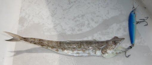
On the way we had some success with trolling first catching a small but aggressive fish which we have problems identifying - and threw back as it was too small to eat.


The next two fish - a Blue Runner (a type of Jack)


and a Cero ( Makerel family ) proved to be very good to eat.


The channel from Spence Rock to Cave Cay was very hairy - we were quite close to high water and we went over patches of just 1.3 meters water depth - we draw 1.2 meters with the board up. Admittedly it was Neaps so at Springs we would have more water, but, as this is the only route out of the Bight to the North, we can see why not many boats venture this way.

6 April we skirted around the banks to the west off West End - the western tip of Little Abaco - and anchored for the night in a very sheltered anchorage between Crab Cay, Little and Great Abaco (26deg 55.05 N 077deg 35.30W).

7 April we motored down to the delightful Manjack Cay and anchored near Rat Cay (26deg 49.22N 077deg 21.97W.

Had a great hike through the wooded trail to Ocean Beach


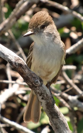
and had a close encounter with a delightful Flycatcher (which does not quite fit any of the bird plates in our superb Petersen Field Guide)


Then along the radiant white Ocean Beach and round the northern tip of the cay.


Along the beach came across some Wilson's Plovers.


With yet another cold front forecast for Friday 9 April, we decided to up-anchor at 0645 this morning and motor the 5 miles to the hurricane hole of Black Sound on Green Turtle Cay. There we we lucky to be able to take the last mooring from Black Sound Marina for the reasonable price of 10 US dollars/ night. Amazingly we are picking up excellent WiFi signals on the boat so have the additional benefit of internet.

We had a walk through the neat closeby settlement of New Plymouth .

Saturday, March 27, 2010

Sail Bahamas Georgetown to Little Farmers Cay 26 March 2010


25th March the pleasant Easterly 4 Bft wind appeared as predicted by Chris Parker, our weather man and we upanchored at 0730hrs . Had a very pleasant beam to broad reach sail up the Exuma Sound for 36 miles to the Little Farmers Cay Cut. Negociated this on the flood tide and called up Ocean Cabin on VHF 16 for a mooring as the anchorages are not too good here and there is a strong ebb and flood currant through the anchorage with many shallow areas and there is a possibilty of another front passing over this evening.
Terry from OC called out bearings to follow to lead us between the reefs and sand banks - however, was not too happy blindly following his instructions so tried to work it out from the charts what we could see. The flood pushed us a bit closer to the sand bank than we should have been, but with Dutch Link's only 4 foot draught, we made it to the mooring without problem. Later dinghied over to Ocean Cabin and found out that Terry could not see us when he was giving his instructions - so very happy that we had done our own thing.

Little Farmers Cay is a very beautiful spot and all the islanders are very friendly. The island is very small and in about 90 minutes one can cover most of it. It does have an airstrip, however, which just looks as though it is part of the road system - J simulated a landing.


Rays circled around under the dinghy feeding off the parts of fish being cleaned above

Monday, February 22, 2010

Sail Bahamas Bimini to Nassau, New Providence Island 22 Feb 2010


20 Feb Had a leasurely stroll around the southern tip of North Bimini.


Encountered huge numbers of stranded Portuguese Men of War jellyfish on the coral sand beach - like small balloons.


Further along a wreck was rusting away hard against the coral - reminder of what can happen.


Alice town looks as though the downturn in the economy has hit it quite badly with many of the buildings either in ruins or in need of repair. The marina where we moored is almost empty - however this is low season for them and we understand from chatting to a local man that they are quite resilient to the economic whims - and there more than enough food in the ocean for them to survive.


Left Bimini at 0900hrs in the company of S/V Just Imagine and S/V Vespera and headed north for North Rock. There we turned to the right and headed eastwards over the Great Bahama Banks, a most amazing feature. The Banks are a huge coral sand plateau with water depths averaging around 5 meters stretching in the north from Bimini 100 miles eastwards to the Berry Islands and over 200 miles southwards.

It feels somewhat unreal traveling such long distances in such shallow but exposed water which is so clear you can see the bottom not far below you. We had almost perfect weather - 10 kts wind and blue skies surrounded by calm turquoise water - what made it not quite perfect was that the wind was on the nose so motoring. The sunset was amazing. By 2000hrs we had covered the 60 miles from North Rock to the NW shoals, a few miles west of deep water.


There we dropped anchor in the dark some 1 1/2 miles north of the track most boats take and a bit sheltered from any easterly swells by the shoals (anchor position 25deg 31.49N 078deg 13.98W), in the middle of nowhere with no land in sight - a surreal experience - under a starry sky. Soon after we anchored, S/V Just Imagine and S/V Vespera anchored close by - very comforting to have some company in such an exposed place. After an almost motionless night we raised the anchor at dawn (0600hrs) and motor sailed into the sunrise. Had originally planned to sail to Chub Cay but did not like the look of the anchorages there bearing in mind the squally weather forecast for the coming days .

So we changed course for Nassau where we anchored at 1630 hrs on Sun 21 Feb. (anchor position 25deg 04.725N 077deg 19.688W) with the famous Atlantis Hotel in the background. Took 4 attempts to find a place to anchor - first 3 attempts were in an area with thin sand and rocks. Plan to stay here until our son Richard arrives on 1st March.

Have not been ashore yet - rained all day yesterday 22 Feb. Forecast is for rain to stop later this morning 23 Feb.